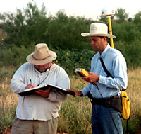
THC archeologists Randy Vance (left)
and Brett Cruse use a Global Positioning system receiver
to record the locations of artifacts. Photo courtesy
of the Texas Historical Commission.
Click images to enlarge
|
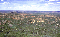
Scene of the Battle of Red River
site and surrounding environs. Photo courtesy of the
Texas Historical Commission.
|
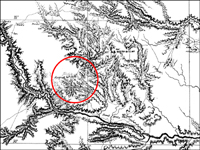
Portion of an 1875 map showing the
general location of the Battle of Red River. The running
battle covered a distance of some 12 miles. Photo courtesy
of the Texas Historical Commission.
|

Contour map of site of the Battle
of Lyman's Wagon Train showing the distribution of Indian
and U.S. Army cartridges and bullets. Courtesy of the
Texas Historical Commission.
|
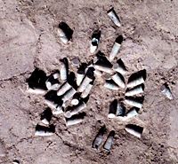
A cluster of unfired Spencer cartridges
at the Battle of Sweetwater Creek site. Photo courtesy
of the Texas Historical Commission.
|
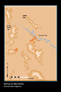
Distribution of Parrott Shell impacts at the Battle of
Red River site, based on artifacts.
|
|
The Red River War led to the final confinement
of the southern Plains Indians on reservations in Indian Territory.
With their removal from Texas, the western half of the state
was opened to Anglo-American settlement.
Recognizing the historical significance of
the Red River War, the Archeology Division of the Texas Historical
Commission (THC) initiated the Red River War Battle Sites
Project in 1998. Our goal was to precisely locate and document
the more significant sites, to nominate them for inclusion
in the National Register of Historic Places and to evaluate
each of the sites for heritage tourism potential. During 1998
and 1999, THC archeologists conducted archeological investigations
at the sites of the battles of Adobe Walls, Red River, Lyman's
Wagon Train, Buffalo Wallow, and Sweetwater Creek.
The two seasons of fieldwork at the Red River
War battle sites were tremendously successful. More than 3,000
battle-related artifacts were recovered and precise boundaries
for the battle sites were identified. For the most part, the
investigations have shown that the sites have remained relatively
undisturbed during the more than 125 years since the battles
occurred. As result, we have new interpretations about specific
battle events and information regarding arms and ammunition
used by the U.S. Army and the Southern Plains Indians. The
investigations are also serving to corroborate some of the
historical accounts of the battles, while contradicting other
historical records. Analysis of the recovered artifacts suggests,
for example, that there were not as many Indian participants
at the battles and they were not as well armed as some of
the military reports indicate.
The archeological methods that were used during
the investigations of the battle sites involved several steps.
First, the archeological team, equipped with metal detectors,
systematically scanned the study area for metal artifacts.
When the metal detectors indicated the presence of a metal
object buried in the ground or on the surface, that place
was marked with a surveyor's pin flag. The metal object was
then excavated and left in place. If the artifact appeared
to be related to the battle, it was assigned a unique identification
number. This number was written on the pin flag, and the flag
was left in place so the artifact could be recorded. Each
artifact was then mapped in place and collected. To map the
artifacts we used a Global Positioning System (GPS) receiver
with sub-meter accuracy. The GPS data was then imported into
a computer-mapping program and overlaid onto topographic maps
to produce precise maps showing the location of each battle-related
artifact.
The archeological investigations at the battle
sites have provided a clearer picture of how the battles unfolded,
including the positions on the battlefields of the Army soldiers
and the Indian warriors, as well as the lines of advance and
retreat of the combatants. The investigations have served
to support some of the historical accounts of the battles,
while questioning other accounts. For example, the investigations
at the Battle of Red River site have substantiated the historical
accounts that the battle was a running battle that covered
a distance of some 12 miles before the Indians broke away
and escaped up Tule Canyon. Our studies also provided conclusive
evidence that the Army indeed used the Gatling gun during
the battle, which marks the first time the weapon was used
in combat west of the Mississippi River and the first time
it was used against Native Americans.
Our data also indicates that the Indians may
not have been as well armed as many of the military documents
and reports seem to suggest. At every battle site investigated
we discovered that there were approximately four U.S. Army
cartridges recovered from the sites for every one Indian cartridge.
In addition, we found that the majority of the Indian cartridges
were Spencers of types that were not manufactured after 1866,
a full eight years prior to battles. This suggests that the
Indians were conserving their ammunition and using it only
sparingly.
Future Directions for the Red River War Project
Military reports, maps and other historic documents
have provided critical information on the Red River War of
1874-1875. Artifacts and their distribution at the battle
sites have filled in many other important details. But to
fully understand what happened during the Red River War the
Indian perception of the events is needed. Army officials
interrogated some of the tribal leaders after the war's end,
and these interviews appear in Army records. The THC team
is gathering and reviewing military documents for details
about the Indian leaders who participated in the battles.
There may be other tribal stories that have been passed down
through the generations since the war. THC plans to make contacts
with the tribes that were involved with the conflict. If tribal
accounts of the war exist and the Indians are willing to share
them, the stories will be recorded. These stories would surely
contribute to a more complete understanding of this chapter
of Texas history.
The results of the THC's Red River War Project
will be reported in a variety of ways. The information will
be published and a plan will be developed with area museums
to create a series of interpretive exhibits about the war.
It is important to share the project results in this way since
the battle sites investigated by the THC are all located on
private property-on working ranches in most cases-with no
public access. By creating partnerships with museums in the
region, students, history buffs, and interested travelers
will be able to learn more about the Red River War.
|
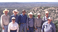
The Red River War Battle Sites Project
archeological crew. Left to right, Brett Cruse, Pat
Mercado-Allinger, Rusty Winn, Luis Alvarado, Rolla Shaller,
Lee Allen, Alvin Linn, Randy Vance. Photo courtesy of
the Texas Historical Commission.
|
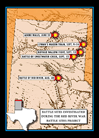
Red River War battle sites investigated
by THC archeologists. Courtesy of the Texas Historical
Commission.
|
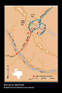
Lines of U.S. Army advance and Indian
retreat at the Battle of Red River site. Photo courtesy
of the Texas Historical Commission.
|
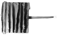
A U.S. Army model 1874 curry comb
found during survey of the sites. Photo courtesy of
the Texas Historical Commission.
|
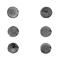
Firing pin marks on cartridges. Top,
left to right: Spencer cartridge with a Ballard block
type firing pin imprint; .50-70 cartridge struck with
a Sharp's firing pin. Middle, left to right, Spencer
cartridge struck twice; Spencer cartridge with a Jocelyn
firing pin imprint. Bottom, left to right, Spencer cartridge
struck by a Sharp's firing pin but fired in a Spencer;
a standard Spencer firing pin. Photo courtesy of the
Texas Historical Commission.
|
|